YHA Street


This site does not currently take bookings here on Pitchup.com.
If you are the owner of this site, start taking bookings through Pitchup.com.
It's free, quick and easy!
 Add your business details
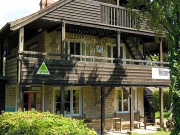
- Glamping units in the scenic grounds of a Swiss-style chalet hostel
- A five-minute drive from Street's Clarks Village and 15 to Glastonbury
- Self-catering kitchen, dining area, small shop, board games


 English
Nearby sites that are bookable on Pitchup.com
Unfortunately, we have no nearby bookable sites.
Want to know more about camping in Somerset?
- 9 Best Places to Walk in Somerset
- Exmoor Area Guide
- 8 Dog-friendly Somerset Beaches
- 5 of Somerset's Best Nature Reserves
- The Best Relaxed Walks on Exmoor
- The 10 Best Beaches In Somerset
- South West England Area Guides
- How To Walk The South West Coast Path On A Budget
- The Ultimate South West England Camping Guide
- Pitchup.com's camping guide
- Essential camping checklist
Features
Dogs allowed
Leisure on site
Bar or club house Cycle hire Evening entertainment Fishing Fitness centre Games room Indoor swimming pool Kids' club On-site restaurant/cafe Outdoor swimming pool Play area TV room Take away Tennis WatersportsAmenities on site
Bath available Composting toilet Dog park Drying room Food shop Free wifi Ice pack freezing Internet access Launderette Parent & baby washroom Pick-up from public transport Portable toilet Pub toilets Public telephone Shower available Toilet block Washing-up area WifiGroups welcome
D. of E. welcome Family friendly Motorcycle friendly Single-sex groups welcome Student groups welcomeRules
Barbecue provided Barbecues allowed Campfires allowed Commercial vehicles allowed Dogs allowed Dogs allowed all yearThemes
Walkers' paradiseUtilities
Charging facilities Chemical disposal Electric car charging point(s) Gas cylinders available Recycling available Renewable energyNearby amenities
Bar nearby Dog walk nearby Public transport nearby Shop nearbyType
Tiny (1-10 pitches)Nearby leisure
Outdoor pool nearby Restaurant nearbyLocation
YHA Street
Ivythorn Hill
Street
Somerset
England
BA16 0TZ
 Directions
 Timezone
Europe/London BST (GMT+01:00)
GPS
51.10816°N
2.7433°W
Route directions
Nearest transport
 Coach
Coach Rail
Rail Ferry
Ferry Airport
Please note: All distances on this page are calculated "as the crow flies" - please check actual distance depending on your mode of travel using the Get directions button above.
Local attractions
Food and drink
- The King Alfred Pub 1.1 mi
- Elms Inn Pub 1.2 mi
- The Lantokay Pub 1.2 mi
- PizzaExpress Restaurant 1.3 mi
- The Castlebrook Pub 1.3 mi
- The Bear Inn Pub 1.4 mi
- Wagamama Restaurant 1.4 mi
- Prezzo Restaurant 1.5 mi
- Bill's Restaurant 1.5 mi
- The Royal Oak Pub 1.5 mi
Groceries
- Heck's Farmhouse Cider Off-licence 0.9 mi
- Lidl Supermarket 1.4 mi
- Sainsbury's Supermarket 1.4 mi
- The Food Warehouse Supermarket 1.4 mi
- ALDI Supermarket 2.4 mi
- Tesco Supermarket 2.5 mi
- Morrisons Supermarket 2.8 mi
- Earthfare Supermarket 3 mi
- RSPB Ham Wall Visitor Centre Drinks shop 3.6 mi
- Londis Supermarket 3.7 mi
Parks and play
- Wraxhill Park 0.9 mi
- Merriman Park 1 mi
- King Arthur's Forest Adventure Play Park Playground 1.4 mi
- Walton Park 1.6 mi
- Butleigh Village Green park 2.6 mi
- Butleigh Playground 2.6 mi
- Abbey Park Playground 2.8 mi
- Abbey Park 2.9 mi
- Glastonbury Tor park 3.1 mi
- Manor House Green park 3.2 mi
Family days out
- The Chalice Well and Gardens Visitor attraction 2.9 mi
- King Arthur's Tomb Visitor attraction 2.9 mi
- Glastonbury Thorn Tree Visitor attraction 3 mi
- St. Michael's Tower Visitor attraction 3.2 mi
- Meare Fish House Visitor attraction 4.6 mi
- Greylake Nature Reserve Visitor attraction 5.1 mi
- Shapwick West Visitor attraction 5.4 mi
- Avalon Marshes Visitor Centre Visitor attraction 5.5 mi
- Westhaý Visitor attraction 5.9 mi
- Lytes Cary Visitor attraction 6 mi
- The Bishop's Palace Castle 8.3 mi
- Somerset Reindeer Ranch Zoo 9.7 mi
Public transport
- Collard Hill 0.3 mi
- Pine Close 0.3 mi
- Goss Drive 0.4 mi
- Slugg Hill 0.4 mi
- Brookside School 0.6 mi
- Smithfield Road 0.6 mi
- Green Lane Avenue 0.7 mi
- Pearmain Road 0.7 mi
- Brooks Road 0.9 mi
- Robins Way 0.9 mi
What’s nearby
- The Bayliss Centre Shopping centre 1.2 mi
- Clarks Village Shopping centre 1.4 mi
- The Gauntlet Shopping centre 3 mi
- Brunel Shopping Precinct Shopping centre 3.8 mi
- Long Sutton Village Shop General shop 5.6 mi
Local services
- HSBC UK Cashpoint 1.2 mi
- Vine Surgery Doctors 1.3 mi
- Boots Pharmacy 1.3 mi
- Tout's Pharmacy Street 1.3 mi
- Sainsbury's Fuel station 1.3 mi
- Sainsbury's Bank Cashpoint 1.4 mi
- Bank Machine Cashpoint 1.5 mi
- Shell Fuel station 2.5 mi
- Morrisons Petrol Station Fuel station 2.7 mi
- MFG Energy Charging station 2.7 mi
Must see
Clarks Village 1.4 mi
Glastonbury Abbey 2.9 mi
Glastonbury Tor 3.2 mi
Fleet Air Arm Museum 7.8 mi
Wells Cathedral 8.3 mi
National Trust
Stembridge Tower Mill 4.2 mi
West Pennard Court Barn 4.4 mi
Lytes Cary Manor 5.8 mi
Priest's House 6.8 mi
Tintinhull Garden 9.3 mi
Cycle routes
Find local routes on the National Cycle Network - over 12,000 miles of cycling routes.
Other
Glastonbury 2.8 mi
HAM WALL (INDICATIVE BOUNDARY ONLY) 3.2 mi
Baltonsborough - West Lydford - Southwood - Baltonsborough 3.8 mi
Battle of Langport, 1645 5 mi
GREYLAKE (CURRENT BOUNDARY FROM 31/03/2003) 5.7 mi
Local events
- Glastonbury Festival (Wednesday, 23 June 2027 – Wednesday, 23 June 2027)
Glastonbury, Somerset 7.7 mi
Please note: All distances on this page are calculated "as the crow flies" - please check actual distance depending on your mode of travel using the Get directions button above.
Reviews
No reviews yet.
Frequently asked questions
- Does YHA Street have a swimming pool? No View all features
- Is YHA Street dog friendly? Yes View all features
- What attractions are near YHA Street? Once you’ve ticked the top nearby sightseeing spots off your list, it's time to concentrate on what else Somerset has in store: first, try spotting birds and otters at Shapwich Heath National … Read more
- When can I check in and check out of YHA Street?
Read moreOn-site accommodation Arrive: 5 p.m. – 9 p.m. Depart by: 10 a.m.