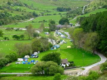
Tyllwyd Campsite


This campground does not currently take bookings here on Pitchup.com.
If you are the owner of this park, start taking bookings through Pitchup.com.
It's free, quick and easy!
Campground type
Languages spoken
English
Welsh
Nearby parks that are bookable on Pitchup.com
Unfortunately, we have no nearby bookable campgrounds.
Want to know more about camping in Ceredigion?
Features
Dogs allowed
Campfires allowed
Leisure on park
Bar or club house Cycle hire Evening entertainment Fishing Fitness centre Indoor swimming pool Kids' club On-site restaurant/cafe Outdoor swimming pool Playground Recreation room/arcade TV room Takeout Tennis WatersportsAmenities on park
Bath available Car parking by site/unit Composting toilet Dog park Drying room Free wifi Grocery store Ice pack freezing Internet access Laundromat Parent & baby washroom Payphone Pick-up from public transport Portable toilet Pub toilets Restrooms Shower available Washing-up area WifiGroups welcome
Family friendly Motorcycle friendly Scouts welcome Single-sex groups welcome Student groups welcomeRules
Barbecue grills allowed Barbecue provided Campfires allowed Commercial vehicles allowed Dogs allowedThemes
Hikers’ paradise Peaceful Remote location Spectacular sceneryUtilities
Charging facilities Dump station Electric car charging point(s) Propane/gas cylinders available Recycling available Renewable energyNearby amenities
Bar nearby Dog walk nearbyType
Farm Small (11-25 sites)Accessibility
Disabled facilitiesLocation
Tyllwyd Campsite
Rhayader
Cwmystwyth
Aberystwyth
Ceredigion
Wales
SY23 4AG
Timezone
Europe/London +0100 (GMT+01:00)
GPS
52.3564°N
-3.7547°W
Nearest transport
Please note: All distances on this page are calculated "as the crow flies" - please check actual distance depending on your mode of travel using the Get directions button above.
Local attractions
Water quality at nearby bathing waters
| Name | Distance | Type | 2020 | 2019 | 2018 | 2017 |
|---|---|---|---|---|---|---|
| Aberystwyth North | 14.6 mi | Sea | Excellent | Good | Excellent | Excellent |
| Aberystwyth South | 14.6 mi | Sea | Good | Good | Good | Good |
| Clarach South | 14.7 mi | Sea | Good | Good | Good | Good |
| Borth | 15.7 mi | Sea | Excellent | Excellent | Excellent | Excellent |
| Llanrhystud | 17.8 mi | Sea | Excellent | Excellent | Excellent | Excellent |
Data source: European Environment Agency
Must see
Vale of Rheidol Railway (Aberystwyth) 14.3 mi
MOMA Wales - Y Tabernacl 16.8 mi
Rheilffordd Talyllyn Railway 21.1 mi
Llanerchaeron - National Trust 22.2 mi
Dolaucothi Gold Mines - National Trust 23.1 mi
National Trust
Dolaucothi Gold Mines 23.1 mi
Cycle routes
Find local routes on the National Cycle Network - over 12,000 miles of cycling routes.
Other
The Arch Car Park - Pen lan fawr - The Arch Car Park 2.6 mi
Pont ar Elan - Esgair y Llwyn - Cerrig Llwydion - Pont ar Elan 6.3 mi
Penybont - North Lookout - South Lookout - Penybont 8.1 mi
Penybont - Esgair Perfedd - Crug1 Ci - Penybont 8.1 mi
Black Covert Walk 1 - Aberystwyth 8.6 mi
Please note: All distances on this page are calculated "as the crow flies" - please check actual distance depending on your mode of travel using the Get directions button above.
Reviews
No reviews yet.
Frequently asked questions
- Does Tyllwyd Campsite have a swimming pool? No View all features
- Is Tyllwyd Campsite dog friendly? Yes View all features