The Best Walks in the North York Moors
With more than 500 square miles of heather-covered moorland, 26 miles of coastline and over 1000 miles of footpaths, there’s no doubt that the North York Moors is a great place for a walk. The national park’s superb walking page is a great resource, listing more than 50 routes in the park, all with descriptions, directions and downloadable GPX files to help you find your way.
Our selection of the best North York Moors walks takes in a dramatic coastal loop at Robin Hood’s Bay, historic medieval ruins, waterfalls, woodland and open moorland with sensational views. All you have to do is choose the one that appeals to you.
The best walk in the North York Moors
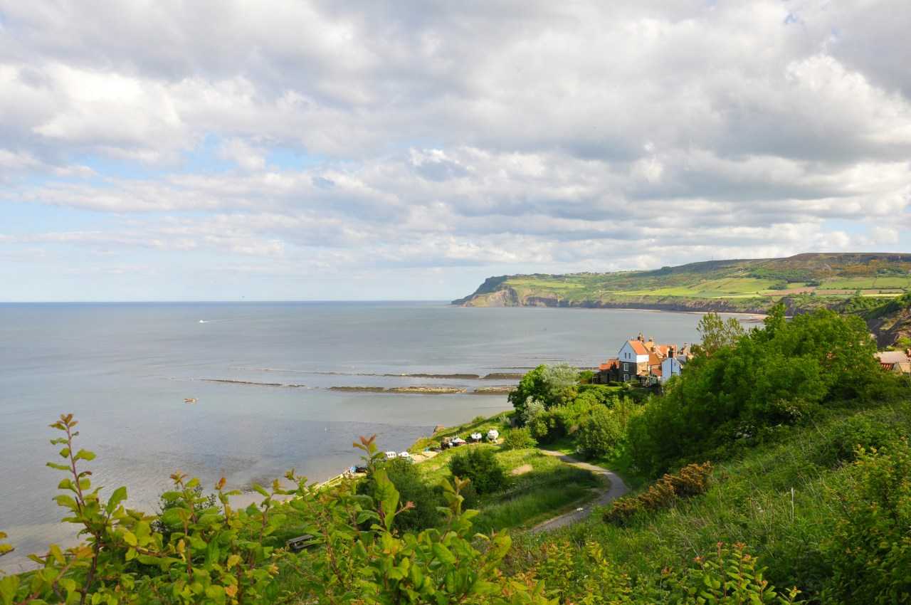
Robin Hood’s Bay and Maw Wyke (circular)
Distance: 5.8 miles (9 km)
Time: approx 3-4 hours
Difficulty: Easy
Start: Station car park, Robin Hood’s Bay
On the coast between Whitby and Scarborough, Robin Hood’s Bay is a pretty fishing village with a history of smuggling in the 1800s and is a constant feature on recommendations for the best walks in the North York Moors. Although it’s on the long side for a ‘walk’, this superb route is our pick due to its fabulous coastal views and because (perhaps with a small amount of coaxing) its largely flat terrain makes it family friendly too.
The route, with fabulous views of the coast, the cliffs and the North Sea, follows the well-signposted Cleveland Way from Robin Hood’s Bay along the cliff top all the way to the inlet of Maw Wyke. Look out for seabirds including kittiwakes, herring gulls and fulmars, as well as cormorants fishing in the water below. At Maw Wyke you turn inland and follow the Cinder Track – the former Scarborough to Whitby railway line – through woodland and countryside all the way back to the village. If you need to stop for a quick rest, or just want to admire the view, the holiday park at Maw Wyke has a cafe/bar (open March to October) and there are several convenient benches along the Cinder Track.
If you’re interested in discovering more of the Cleveland Way, and other longer hikes in the national park, check out Pitchup’s guide to the best hikes in the North York Moors.
Best circular walks in the North York Moors
We’ve picked two of the best circular walks in the North York Moors – short but beautiful, and ideal for families.
May Beck and Falling Foss
Distance: 2 miles (3.2 km)
Time: approx 1.5 hours
Difficulty: Easy
Start: May Beck car park
This gentle 2-mile loop follows a tumbling stream through the conifers and older oak woodland of Sneaton Forest to the 30-foot Falling Foss waterfall. It’s a great choice for families and nature lovers, and it's clearly signposted, with the added bonus of a charming tea room in an 18th-century cottage moments from the cascade. From here, you can head uphill to the Hermitage, a curious cave carved into a large boulder, said to be the former home of an 18th-century hermit. If you’re lucky, you might even spot deer or otters en route.
There’s plenty to keep children interested, from paddling in the stream and the pool below the waterfall to bridges to play on and a play area at the tea rooms. A ‘fairy trail’ leads through the woods to the Hermitage, where they can sit in the ‘wishing chairs’ on top of the rock – sit in the first chair to make a wish, and the second to make it come true. The woods are carpeted in bluebells and purple orchids in spring, and decked out with golden leaves in autumn.
The national park website has an excellent page that provides comprehensive directions and a GPX file of the route.
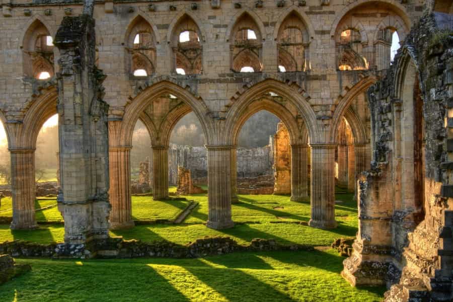
Rievaulx Loop
Distance: 2.5 miles (4 km)
Time: 1-2 hours
Difficulty: Easy
Start: Rievaulx Abbey car park
Winding through the woodlands and pastures around the River Rye, this easy loop trail is suitable for families and takes in two gems of local cultural heritage. During spring you can spot primroses, snowdrops and bluebells in Ashberry Wood, and look out for kingfishers and deer along the way.
The trail starts from Rievaulx Abbey, a spectacular 12th-century Cistercian ruin, and en route there are great views of Rievaulx Terrace, a delightful 18th-century landscaped garden which is home to two temples – handsome 18th-century follies with frescoes and ornate plasterwork. Both are well worth some extra exploration if you have some energy left after your walk.
Full details of the route and a downloadable GPX file are available on the national park’s website.
Other easy walks in the North York Moors
Our pick of easy walks in the North York Moors brings some fabulous views, and includes a wheelchair-accessible route along Sutton Bank.
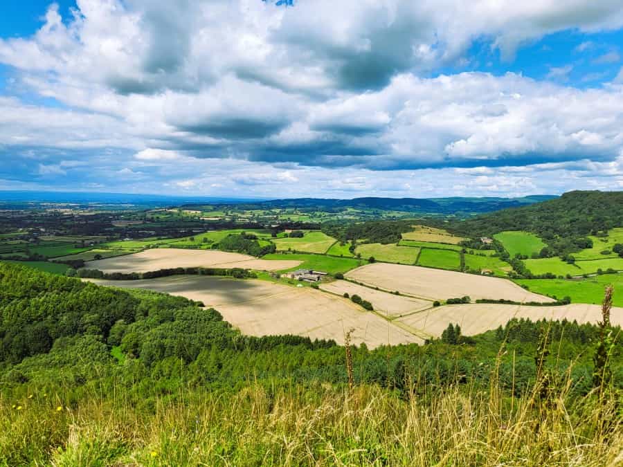
Sutton Bank and Kilburn White Horse
Distance: 3.5 miles (5.5 km) out and back
Time: approx 2 hours
Difficulty: Easy
Start: Sutton Bank National Park Centre
This easy walk takes in another section of the long-distance Cleveland Way and the majority is accessible to assisted wheelchair users. It has stunning views across the moors and the Vale of York from the Sutton Bank escarpment, as well as visiting the huge 19th-century White Horse cut into the hill. As an added bonus you can watch the gliders from the Yorkshire Gliding Club taking off and riding the air currents above the escarpment. Unsurprisingly, it’s one of the North York Moors’ most popular walks.
You can borrow a wheelchair or hire a tramper (book in advance) at the National Park Centre at Sutton Bank, where kids can play on the treehouses, castle and sandpit at the adventure playground. If you still have energy to burn, you can also hire bikes (Thursday to Monday) to explore more of the area on designated cycling trails.
The visitor centre has maps and guides, and you can download full details of the route from the national park’s website.
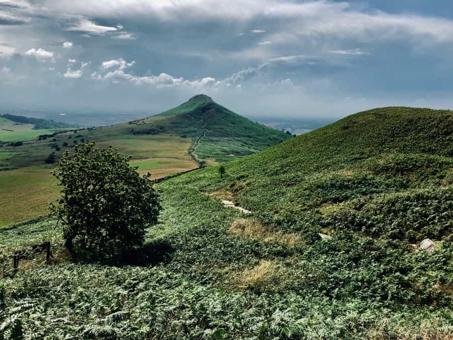
Lord Stones Walk
Distance: 2.8 miles (4.5 km)
Time: approx 2 hours
Difficulty: Moderate
Start: Lord Stones Country Park
This short (but occasionally steep) loop is easy to follow and takes you up onto a spectacular area of open moorland with panoramic views that typifies the beauty of the National Park. There are great views of the iconic Roseberry Topping and the Cleveland Plain on the way out, and from the impressive stone seat at the summit of Cringle Moor on the return. It starts from the Lord Stones Country Park, home to the ancient boundary stone with prehistoric carvings that gives the trail its name, and a handy stop for lunch on the way back.
You can download a GPX file and details of the route from the national park website.
Levisham Moor and the Hole of Horcum
Distance: 5.3 miles (8.5 km)
Time: 2-3 hours
Difficulty: Easy
Start: Saltergate car park
Another classic North York Moors walk, this easy 5-mile loop from Saltergate has great views of the Hole of Horcum, a huge natural amphitheatre that’s another of the park’s iconic features, and passes Bronze Age and Iron Age archaeological sites on the way across the ancient monument of Levisham Moor. It's worth a short detour to the ruined Skelton Tower to admire the fabulous view of Newtondale and the North Yorkshire Moors Railway, where you might see a passing steam train.
Full details of the route (including the diversion to Skelton Tower) are available on the national park’s website.
With incredible views, fascinating historic sites and plenty of treats for families, we think that the North York Moors are home to some of the best walks in the UK. But don’t just take our word for it – it's time to lace up your boots and find out for yourself.
The North York Moors National Park is also an idyllic place to camp. If you’re thinking of pitching a tent between walks, check out Pitchup’s range of the best campsites in the North York Moors.