Low Bollihope Farm
Dieser Platz nimmt auf Pitchup.com gerade keine Buchungen entgegen.
Wenn Sie der Besitzer dieses Campingplatzes sind, können Sie mithilfe von Pitchup.com zusätzliche Buchungen erhalten.
Es ist kostenlos, schnell und einfach!
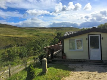
- Schickes Chalet direkt am Weardale Way in der Nähe von Frosterley
- Eine halbe Stunde Fahrt von Durham und Hamsterley Forest
- Gut ausgestattete Küche, WC und Balkon
Art des Platzes
Gesprochene Sprachen
![]() Englisch
Englisch
Nächstgelegene Plätze

Leider gibt es in der Umgebung keine buchbaren Plätze.
Co. Durham: Mehr übers Campen erfahren?
Ausstattung
![]() Hunde nicht gestattet
Hunde nicht gestattet
Freizeiteinrichtungen am Platz
Abendunterhaltung
Angeln
Bar oder Clubhaus
Eigenes Restaurant/Cafe
Fahrradverleih
Fernsehraum
Fitnesscenter
Freischwimmbecken
Gerichte zum Mitnehmen
Hallenbad
Kinderclub
Spielplatz
Spielzimmer
Tennis
Wassersport
Platzausstattung
Abholung vom Bahnhof/Busbahnhof
Auto-Parkmöglichkeit am Stellplatz/bei der Unterkunft
Badewanne vorhanden
Barrierefreie Einrichtungen
Dusche vorhanden
Eisbeutel-Kühlservice
Familienwaschräume
Geschirrspülraum
Gratis WLAN
Internet-Anschluss
Komposttoilette
Lebensmittelgeschäft
Mobiltoilette
Park für Hunde
Sanitärgebäude
Toiletten im Pub
Trockenraum
WLAN
Waschküche
Öffentliches Telefon
Gruppenregelungen
Familienfreundlich
Frauen-/Männergruppen willkommen
Motorradfreundlich
Studentengruppen willkommen
Regeln
Grill wird zur Verfügung gestellt
Grillen gestattet
Hunde gestattet
Hunde nicht gestattet
Lagerfeuer gestattet
Nutzfahrzeuge gestattet
Themen
Eindrucksvolle Landschaft
Friedlich
Naturparadies
Ruhige Lage
Wald
Wanderparadies
Ausstattung
Chemie-WC Entsorgung
Erneuerbare Energie
Gasflaschen-Service
Ladestation(en) für Elektroautos
Ladestationen
Recycling vorhanden
Einrichtungen in der Umgebung
Bar in der Nähe
Bauernmarkt in der Nähe
Gassi gehen in der Nähe
Lebensmittelgeschäft in der Nähe
Öffentliche Transportmittel in der Nähe
Typ
Bauernhof
Mini (1-10 Stellplätze)
Freizeitaktivitäten in der Umgebung
Fahrradverleih in der Nähe
Freibad in der Nähe
Kanus/Kajaks in der Nähe
Klettern in der Nähe
Mountainbike-Routen in der Nähe
Radfahren in der Nähe
Reitmöglichkeit in der Nähe
Restaurant in der Nähe
Lage
Low Bollihope Farm
Low Bollihope
Frosterley
Co. Durham
England
DL13 2SY
Zeitzone
Europe/London +0000 (GMT+00:00)
GPS
54,71239°N
-1,97728°W
Wegbeschreibung
Öffentliche Verkehrsmittel in der Nähe
Bitte beachten: Alle auf dieser Seite angegebenen Entfernungen sind auf "Luftlinien-Basis" berechnet - bitte die exakte Entfernung unter Berücksichtigung des Transportmittels mithilfe des Feldes Wegbeschreibung oben überprüfen.
Sehenswürdigkeiten in der Nähe
Wasserqualität umliegender Gewässer
| Name | Entfernung | Art | 2020 | 2019 | 2018 | 2017 |
|---|---|---|---|---|---|---|
| Seaham Hall Beach | 43,6 km | Meer | N/A | Gut | Gut | Ausgezeichnet |
| Seaham Beach | 43,7 km | Meer | N/A | Gut | Ausgezeichnet | Ausgezeichnet |
| Roker - Sunderland | 45,8 km | Meer | N/A | Ausgezeichnet | Ausgezeichnet | Ausgezeichnet |
| Seaburn - Sunderland | 46,5 km | Meer | N/A | Ausgezeichnet | Ausgezeichnet | Ausgezeichnet |
| Crimdon | 46,8 km | Meer | Gut | Ausgezeichnet | Ausgezeichnet | Ausgezeichnet |
Datenquelle: Europäische Umweltagentur
Must-see
High Force Waterfall 15 km
Barnard Castle 17,8 km
The Bowes Museum 19,3 km
Locomotion:The National Railway Museum at Shildon 23,6 km
Durham Cathedral 26,6 km
National Trust
Gibside 27,9 km
Cherryburn 28 km
Allen Banks and Staward Gorge 36,2 km
Washington Old Hall 36,2 km
Holy Jesus Hospital 37,2 km
Radwege
Umliegende Radwege des Nationalen Radnetzes finden - über 19.000 Kilometer an Radwegen
Andere
Stanhope - Stanhope Dene - Stanhope Burn Mine 4,3 km
Stanhope - Crookledy Crag - Stanhope 4,4 km
Circular Walk by Wolsingham 6 km
Wolsingham and Tunstall Reservoir 6,4 km
Tunstall Reservoir 7,7 km
Veranstaltungen in der Nähe
- Festival of Thrift (Samstag, 21. September 2024 – Samstag, 21. September 2024)
Stockton-on-Tees, England 34,6 km
Bitte beachten: Alle auf dieser Seite angegebenen Entfernungen sind auf "Luftlinien-Basis" berechnet - bitte die exakte Entfernung unter Berücksichtigung des Transportmittels mithilfe des Feldes Wegbeschreibung oben überprüfen.
Bewertungen
Noch keine Bewertungen
- Gibt es im Low Bollihope Farm ein Schwimmbecken? Nein Alle Eigenschaften ansehen
- Ist Low Bollihope Farm hundefreundlich? Nein Alle Eigenschaften ansehen
- Welche Attraktionen finde ich in der Nähe von Low Bollihope Farm? Along its 77-mile length, the Weardale Way roughly follows the course of the River Wear, taking in woods, farmland, moors and villages as it meanders. To make it a bit more manageable … Mehr erfahren
- Wann kann ich im Low Bollihope Farm ein- und auschecken?
Mehr erfahrenUnterkunft vor Ort Ankunft: 14:00 – Jederzeit Abreise bis: 11:30