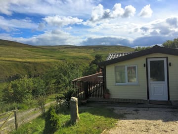
Low Bollihope Farm


No momento, este local não está aceitando reservas aqui no Pitchup.com
Se você é o proprietário deste local, comece a fazer reservas no Pitchup.com.
É grátis, rápido e fácil!
- Chalé moderno perto da trilha Weardale Way em Frosterley
- A meia hora de carro de Durham e da floresta de Hamsterley
- Cozinha bem equipada, banheiros e sacada tipo deck
Tipo de local
Idiomas falados
Inglês
Locais próximos que aceitam reservas via Pitchup.com
Infelizmente não temos locais que recebem reservas automaticamente nos arredores.
Quer saber mais sobre camping em Co. Durham?
Recursos
Não permitido cachorros
Lazer no local
Academia Aluguel de bicicletas Bar ou clube Clube infantil Entretenimento noturno Esportes aquáticos Parque infantil Pescaria Piscina aquecida Piscina externa Restaurante no local Sala de TV Sala de jogos Tele-entrega TênisInstalações no local
Acesso à internet Banheiras disponíveis Banheiro ecológico Banheiro portátil Banheiros no pub Banheiros para famílias Chuveiros disponíveis Congelamento de compressa fria Estacionamento ao lado do local/da unidade Lavanderia Local para lavar louça Mercado Parque para cachorros Prédio de banheiros Sala de secagem Serviço de transfer Telefone público Wifi Wifi grátisGrupos bem-vindos
Familiar Grupos de estudantes bem-vindos Grupos de pessoas do mesmo sexo bem-vindos Motocicletas bem-vindasRegras
Cachorros permitidos Churrasqueira fornecida Fogueiras permitidas Não permitido cachorros Permitido fazer churrasco Veículos comerciais permitidosTemas
Floresta Local remoto Paisagens espetaculares Paraíso natural Paraíso para caminhadas TranquiloServiços
Cilindros de gás disponíveis Eliminação de toiletes químicos Energia renovável Infraestrutura de recarga Ponto(s) para carregar veículos elétricos Reciclagem disponívelInstalações nos arredores
Bar nas redondezas Feira de produtores nos arredores Lojas das redondezas Lugar para passear com cachorros por perto Transportes públicos nas proximidadesTipo
Fazenda Mini (1-10 unidades)Accessibility
Instalações para pessoas com deficiênciaLazer nos arredores
Aluguel de bicicletas nos arredores Canoagem/caiaque nos arredores Ciclovias nos arredores Equitação nas redondezas Montanhismo nos arredores Mountain biking nos arredores Piscina externa nas redondezas Restaurantes nas redondezasLocal
Low Bollihope Farm
Low Bollihope
Frosterley
Co. Durham
Inglaterra
DL13 2SY
Fuso horário
Europe/London +0100 (GMT+01:00)
GPS
54,71239°N
-1,97728°O
Informações de rota
Transporte mais próximo
Observe o seguinte: Todas as distâncias nesta página são calculadas em linha reta - verifique a distância real, dependendo da forma com que você viaja, no botão 'Saiba como chegar' acima.
Atrações locais
A qualidade da água em locais de banho próximos
| Nome | Distância | Tipo | 2020 | 2019 | 2018 | 2017 |
|---|---|---|---|---|---|---|
| Seaham Hall Beach | 43,6 km | Mar | N/A | Bom | Bom | Excelente |
| Seaham Beach | 43,7 km | Mar | N/A | Bom | Excelente | Excelente |
| Roker - Sunderland | 45,8 km | Mar | N/A | Excelente | Excelente | Excelente |
| Seaburn - Sunderland | 46,5 km | Mar | N/A | Excelente | Excelente | Excelente |
| Crimdon | 46,8 km | Mar | Bom | Excelente | Excelente | Excelente |
Fonte de dados: European Environment Agency
Imperdível
High Force Waterfall 15 km
Barnard Castle 17,8 km
The Bowes Museum 19,3 km
Locomotion:The National Railway Museum at Shildon 23,6 km
Durham Cathedral 26,6 km
National Trust
Gibside 27,9 km
Cherryburn 28 km
Allen Banks and Staward Gorge 36,2 km
Washington Old Hall 36,2 km
Holy Jesus Hospital 37,2 km
Ciclovias
Encontre rotas locais na National Cycle Network - mais de 19.000 km de ciclovias.
Outro
Stanhope - Stanhope Dene - Stanhope Burn Mine 4,3 km
Stanhope - Crookledy Crag - Stanhope 4,4 km
Circular Walk by Wolsingham 6 km
Wolsingham and Tunstall Reservoir 6,4 km
Tunstall Reservoir 7,7 km
Eventos locais
- Festival of Thrift (sábado, 21 de setembro de 2024 – sábado, 21 de setembro de 2024)
Stockton-on-Tees, Inglaterra 34,6 km
Observe o seguinte: Todas as distâncias nesta página são calculadas em linha reta - verifique a distância real, dependendo da forma com que você viaja, no botão 'Saiba como chegar' acima.
Avaliações
Nenhuma avaliação ainda.
Perguntas mais frequentes
- O Low Bollihope Farm tem uma piscina? Não Visualizar todas as características
- O Low Bollihope Farm aceita cachorros? Não Visualizar todas as características
- Quais atrações ficam perto do Low Bollihope Farm? Along its 77-mile length, the Weardale Way roughly follows the course of the River Wear, taking in woods, farmland, moors and villages as it meanders. To make it a bit more manageable … Saiba mais
- Quando posso fazer check-in e check-out do Low Bollihope Farm?
Saiba maisAcomodação no local Chega: 14:00 – A qualquer momento Partida às: 11:30