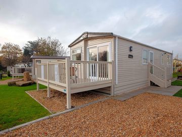
Shireburne Park
Ten obiekt nie przyjmuje obecnie rezerwacji na Pitchup.com.
Jeśli jesteś właścicielem tego obiektu, zacznij przyjmować rezerwacje za pośrednictwem Pitchup.com.
Bezpłatnie, szybko i łatwo!
- Spokojny park w dolinie Ribble z widokiem na Pendle Hill
- Oddalony o 50 minut od Forest of Bowland, Pendle i Yorkshire Dales
- Bar w weekendy, pięć minut jazdy autem od targów Clitheroe i zamku
Rodzaj obiektu
Używane języki
![]() Angielski
Angielski
Chcesz dowiedzieć się więcej o biwakowaniu w: Lancashire?
Funkcje
![]() Psy akceptowane
Psy akceptowane
Zajęcia wypoczynkowe na kempingu
Bar lub klub
Centrum fitness
Klub dla dzieci
Kryty basen
Na wynos
Odkryty basen
Plac zabaw
Pokój z telewizją
Restauracja/kawiarnia na miejscu
Sala gier
Sporty wodne
Tenis
Wieczorna rozrywka
Wypożyczalnia rowerów
Wędkarstwo
Udogodnienia
Automat telefoniczny
Bezpłatne Wi-Fi
Internet
Odbiór ze stacji/lotniska
Park dla psów
Parking obok obiektu/jednostki
Pralnia
Prysznic dostępny
Sklep spożywczy
Suszalnia
Toaleta kompostująca
Toaleta przenośna
Toalety
Toalety w pubie
Udogodnienia dla niepełnosprawnych
Wanna dostępna
Wi-Fi
Wkłady lodowe, mrożące
Zlew
Łazienka dla rodzin z dziećmi
Mile widziane grupy
Dla rodzin
Mile widziane grupy studenckie
Mile widziane grupy tej samej płci
Odpowiednie dla motocykli
Zasady
Dozwolone grillowanie
Dozwolone pojazdy użytkowe
Ogniska dozwolone
Psy akceptowane
Psy akceptowane przez cały rok
Sprzęt do grillowania na wyposażeniu
Motywy
Gastronomiczne specjały
Las
Naturalny raj
Raj dla miłośników spacerów
Spektakularny widok
Spokojna okolica
Usługi komunalne
Dostępne butle gazowe
Energia odnawialna
Recykling dostępny
Sprzęt do ładowania
Stacje ładowania samochodów elektrycznych
Usuwanie chemicznych odpadów
Pobliskie udogodnienia
Bar w okolicy
Publiczny transport w pobliżu
Sklep w okolicy
Wybieg dla psów w pobliżu
Rodzaj
Mini (parcele 1-10)
Zajęcia wypoczynkowe w okolicy
Górskie trasy rowerowe w okolicy
Jazda konno w pobliżu
Kort tenisowy w okolicy
Kryty basen w okolicy
Pole golfowe w okolicy
Restauracja w okolicy
Trasy rowerowe w pobliżu
Wypożyczalnia kajaków w okolicy
Wypożyczalnia rowerów w okolicy
Wędkarstwo w okolicy
Miejsce
Shireburne Park
Edisford Road
Waddington
Clitheroe
Lancashire
Anglia
BB7 3LB
Strefa czasowa
Europe/London +0000 (GMT+00:00)
GPS
53,87442°N
-2,41572°W
Najbliższy transport
Uwaga: Wszystkie odległości na tej stronie są obliczane w linii prostej – sprawdź rzeczywistą odległość, biorąc pod uwagę swój sposób podróżowania i naciskając powyższy przycisk „Wyznacz trasę dojazdu”.
Lokalne atrakcje
Jakość wody w pobliskich kąpieliskach
| Nazwisko | Odległość | Rodzaj | 2020 | 2019 | 2018 | 2017 |
|---|---|---|---|---|---|---|
| Morecambe North | 36,8 km | Ujście | Dobra | Nie dotyczy | Dobra | Dobra |
| Morecambe South | 37,3 km | Morze | Nie dotyczy | Nie dotyczy | Dobra | Dobra |
| Fleetwood | 40 km | Morze | Nie dotyczy | Dobra | Dobra | Dobra |
| Cleveleys | 41,5 km | Morze | Nie dotyczy | Dobra | Dobra | Dobra |
| Bispham | 42 km | Morze | Nie dotyczy | Dobra | Dobra | Dobra |
Źródło danych: Europejska Agencja Ochrony Środowiska
To trzeba zobaczyć
Gawthorpe Hall 11,2 km
Oswaldtwistle Mills 14,2 km
Beacon Fell Country Park 15,9 km
Forest of Bowland 23,6 km
Bronte Parsonage Museum 30,4 km
National Trust
Gawthorpe Hall 11,2 km
Hardcastle Crags 28,4 km
Malham Tarn Estate 29,8 km
East Riddlesden Hall 35 km
Rufford Old Hall 37,1 km
Trasy rowerowe
Znajdź lokalne trasy będące częścią krajowej sieci tras rowerowych – ponad 20 tysięcy kilometrów tras rowerowych.
Inne
Edisford - Brungerly - Chatburn - West Bradford - Edisford 0,6 km
Waddington and the Moorcock by Wadddington Brook 1,5 km
CLITHEROE CASTLE 1,6 km
Journey through the Centre of the Kingdom, Section 1: Clitheroe - Chatburn 1,6 km
Waddington, West Bradford and the Moorcock 1,8 km
Lokalne wydarzenia
- Lytham Festival (środa, 3 lipca 2024 – środa, 3 lipca 2024)
Lytham St Annes, Anglia 39,1 km
Uwaga: Wszystkie odległości na tej stronie są obliczane w linii prostej – sprawdź rzeczywistą odległość, biorąc pod uwagę swój sposób podróżowania i naciskając powyższy przycisk „Wyznacz trasę dojazdu”.
Recenzje
Brak recenzji.
- Czy w Shireburne Park znajduje się basen? Nie Zobacz wszystkie opcje
- Czy w Shireburne Park akceptowane są zwierzęta? Tak Zobacz wszystkie opcje
- Jakie są atrakcje w pobliżu Shireburne Park? For walks and tales of witches, Pendle Hill is half an hour's drive away and paths up to the top start from Barley. To learn about those infamous 17th-century witch trials, head … Czytaj więcej
- Kiedy mogę się zameldować do i wymeldować z Shireburne Park?
Czytaj więcejZakwaterowanie na miejscu Przyjazd: 15:00 – 22:00 Wyjazd przed: 10:30