Low Bollihope Farm
This site does not currently take bookings here on Pitchup.com.
If you are the owner of this site, start taking bookings through Pitchup.com.
It's free, quick and easy!
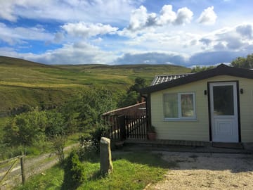
- Smart modern chalet just off the Weardale Way near Frosterley
- Half an hour's drive from Durham and Hamsterley Forest
- Well-equipped kitchen, wetroom and decked balcony
Site type
Languages spoken
![]() English
English
Want to know more about camping in Co. Durham?
Features
![]() No dogs allowed
No dogs allowed
Leisure on site
Bar or club house
Cycle hire
Evening entertainment
Fishing
Fitness centre
Games room
Indoor swimming pool
Kids' club
On-site restaurant/cafe
Outdoor swimming pool
Play area
TV room
Take away
Tennis
Watersports
Amenities on site
Bath available
Car parking by site/unit
Composting toilet
Disabled facilities
Dog park
Drying room
Food shop
Free wifi
Ice pack freezing
Internet access
Laundry
Parent & baby washroom
Pick-up from public transport
Portable toilet
Pub toilets
Public telephone
Shower available
Toilet block
Washing-up area
Wifi
Groups welcome
Family friendly
Motorcycle friendly
Single-sex groups welcome
Student groups welcome
Rules
Barbecue provided
Barbecues allowed
Campfires allowed
Commercial vehicles allowed
Dogs allowed
No dogs allowed
Themes
Bush
Peaceful
Remote location
Spectacular scenery
Walkers' paradise
Wildlife haven
Utilities
Charging facilities
Dump point
Electric car charging point(s)
Gas cylinders available
Recycling available
Renewable energy
Nearby amenities
Bar nearby
Convenience store nearby
Dog walk nearby
Nearby farmers' market
Public transport nearby
Type
Farm
Tiny (1-10 sites)
Nearby leisure
Canoeing/kayaking nearby
Climbing nearby
Cycle hire nearby
Cycling nearby
Horse riding nearby
Mountain biking nearby
Outdoor pool nearby
Restaurant nearby
Location
Low Bollihope Farm
Low Bollihope
Frosterley
Co. Durham
England
DL13 2SY
Timezone
Europe/London GMT (GMT+00:00)
GPS
54.71239°N
-1.97728°W
Route directions
Nearest transport
Please note: All distances on this page are calculated "as the crow flies" - please check actual distance depending on your mode of travel using the Get directions button above.
Local attractions
Water quality at nearby bathing waters
| Name | Distance | Type | 2020 | 2019 | 2018 | 2017 |
|---|---|---|---|---|---|---|
| Seaham Hall Beach | 43.6 km | Sea | N/A | Good | Good | Excellent |
| Seaham Beach | 43.7 km | Sea | N/A | Good | Excellent | Excellent |
| Roker - Sunderland | 45.8 km | Sea | N/A | Excellent | Excellent | Excellent |
| Seaburn - Sunderland | 46.5 km | Sea | N/A | Excellent | Excellent | Excellent |
| Crimdon | 46.8 km | Sea | Good | Excellent | Excellent | Excellent |
Data source: European Environment Agency
Must see
High Force Waterfall 15 km
Barnard Castle 17.8 km
The Bowes Museum 19.3 km
Locomotion:The National Railway Museum at Shildon 23.6 km
Durham Cathedral 26.6 km
National Trust
Gibside 27.9 km
Cherryburn 28 km
Allen Banks and Staward Gorge 36.2 km
Washington Old Hall 36.2 km
Holy Jesus Hospital 37.2 km
Cycle routes
Find local routes on the National Cycle Network - over 12,000 miles of cycling routes.
Other
Stanhope - Stanhope Dene - Stanhope Burn Mine 4.3 km
Stanhope - Crookledy Crag - Stanhope 4.4 km
Circular Walk by Wolsingham 6 km
Wolsingham and Tunstall Reservoir 6.4 km
Tunstall Reservoir 7.7 km
Local events
- Festival of Thrift (Saturday, 21 September 2024 – Saturday, 21 September 2024)
Stockton-on-Tees, England 34.6 km
Please note: All distances on this page are calculated "as the crow flies" - please check actual distance depending on your mode of travel using the Get directions button above.
Reviews
No reviews yet.
- Does Low Bollihope Farm have a swimming pool? No View all features
- Is Low Bollihope Farm dog friendly? No View all features
- What attractions are near Low Bollihope Farm? Along its 77-mile length, the Weardale Way roughly follows the course of the River Wear, taking in woods, farmland, moors and villages as it meanders. To make it a bit more manageable … Read more
- When can I check in and check out of Low Bollihope Farm?
Read moreOn-site accommodation Arrive: 2 p.m. – Anytime Depart by: 11:30 a.m.