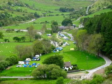
Tyllwyd Campsite


Deze camping neemt momenteel geen reserveringen aan via Pitchup.com.
Als je de eigenaar van deze camping bent, begin dan met boekingen aannemen via Pitchup.com.
Het is gratis, snel en makkelijk!
Parktype
Gesproken talen
![]() Engels
Engels
![]() Welsh
Welsh
Nabijgelegen accommodaties die beschikbaar zijn op Pitchup.com
Helaas, wij hebben geen nabijgelegen boekbare campings.
Voorzieningen
Honden toegestaan
![]() Kampvuur toegestaan
Kampvuur toegestaan
Activiteiten op de camping
Afhaaldienst Avondprogramma Bar of clubhuis Binnenzwembad Buitenzwembad Fietsverhuur Fitnesscentrum Kinderclub Restaurant/café op de camping Speeltuin Spelletjeskamer Tennis Tv-ruimte Vissen WatersportenVoorzieningen op de camping
Afwasruimte Bad aanwezig Boodschappenwinkel Composttoilet Douche aanwezig Draagbaar toilet Droogruimte Gezinsbadkamer Gratis wifi Hondenpark Internetaansluiting Openbare telefoon Toiletgebouw Toiletten in pub Transferservice naar openbaar vervoer Vriezer voor koelelementen Wasserette WifiGroepen welkom
Familievriendelijk Mannen/vrouwengroepen welkom Motorrijders welkom Schoolgroepen welkom Studentengroepen welkomRegels
Barbecue voorzien Barbecues toegestaan Bedrijfswagens toegestaan Honden toegestaan Kampvuur toegestaanThema's
Afgelegen Spectaculaire omgeving Vredig WandelparadijsFaciliteiten
Afvoerpunt chemische toiletten Gasflessen aanwezig Groene energie Oplaadpunt aanwezig Oplaadpunt(en) voor elektrische auto's RecyclingType
Boerderij Klein (11-25 staanplaatsen)Voorzieningen in de buurt
Bar in de buurt Hondenuitlaatplaats in de buurtLocatie
Tyllwyd Campsite
Rhayader
Cwmystwyth
Aberystwyth
Ceredigion
Wales
SY23 4AG
Tijdzone
Europe/London +0100 (GMT+01:00)
GPS
52,3564°N
3,7547°W
Dichtstbijzijnd vervoer
Let op: Alle afstanden op deze pagina zijn hemelsbreed berekend – controleer daarom de werkelijke afstand, afhankelijk van hoe je reist, door op de knop 'Ga naar routebeschrijving' hierboven te klikken.
Lokale bezienswaardigheden
Waterkwaliteit van nabijgelegen zwemwater
| Naam | Afstand | Type | 2020 | 2019 | 2018 | 2017 |
|---|---|---|---|---|---|---|
| Aberystwyth North | 23,5 km | Zee | Uitstekend | Goed | Uitstekend | Uitstekend |
| Aberystwyth South | 23,6 km | Zee | Goed | Goed | Goed | Goed |
| Clarach South | 23,7 km | Zee | Goed | Goed | Goed | Goed |
| Borth | 25,2 km | Zee | Uitstekend | Uitstekend | Uitstekend | Uitstekend |
| Llanrhystud | 28,6 km | Zee | Uitstekend | Uitstekend | Uitstekend | Uitstekend |
Bron gegevens: Europees Milieuagentschap
Populaire bezienswaardigheid
Vale of Rheidol Railway (Aberystwyth) 23 km
MOMA Wales - Y Tabernacl 27 km
Rheilffordd Talyllyn Railway 33,9 km
Llanerchaeron - National Trust 35,7 km
Dolaucothi Gold Mines - National Trust 37,2 km
Nationaal Beheer
Dolaucothi Gold Mines 37,2 km
Fietsroutes
Vind lokale routes op het National Cycle Network - bijna 20.000 kilometer aan fietsroutes.
Anders
The Arch Car Park - Pen lan fawr - The Arch Car Park 4,1 km
Pont ar Elan - Esgair y Llwyn - Cerrig Llwydion - Pont ar Elan 10,2 km
Penybont - North Lookout - South Lookout - Penybont 13,1 km
Penybont - Esgair Perfedd - Crug1 Ci - Penybont 13,1 km
Black Covert Walk 1 - Aberystwyth 13,9 km
Let op: Alle afstanden op deze pagina zijn hemelsbreed berekend – controleer daarom de werkelijke afstand, afhankelijk van hoe je reist, door op de knop 'Ga naar routebeschrijving' hierboven te klikken.
Beoordelingen
Nog geen beoordelingen.
Veelgestelde vragen
- Heeft Tyllwyd Campsite een zwembad? Nee Bekijk alle faciliteiten
- Is Tyllwyd Campsite hondvriendelijk? Nee Bekijk alle faciliteiten