Our Favourite Gwynedd Walks To Try
")
As you might expect from the county that’s home to a large chunk of Eryri (Snowdonia) National Park, Gwynedd is a popular destination for hikers and other outdoor enthusiasts. This north Wales county has heaps of fabulous scenery, and lots of peaceful space too – this is one of the biggest counties in Wales, and also one of its least populated.
Naturally the national park draws much of the attention, but there’s much more to this gorgeous area than just that – including an awful lot of gorgeous coastline to explore. And that means there should be something for all sorts of visitors here, whether you’re after serious mountain scrambles or ice-cream-fuelled seaside strolls.
To help you find the best places to explore in the area, we’ve come up with this list of our favourite Gwynedd walks to try – there should be something for everyone here, from hardcore hiking to gentle family-friendly wanders.
If you’re visiting the area and want somewhere to stay, it’s worth considering a campsite or glampsite. These scenic surroundings make a great backdrop to an outdoor stay, and Pitchup has some great options for all budgets and holiday styles. Take a look at the full range of Gwynedd places to stay by clicking the link below.
Rhosgadfan and Moel Tryfan
Follow in the footsteps of three adventurous pioneers with a walk from the village of Rhosgadfan to the peak of Moel Tryfan. The route is relatively gentle in ascent and passes through some particularly rugged and remote landscapes.
The slopes of Moel Tryfan are dotted with abandoned slate quarries, one of which – Cors y Bryniau – gave its name to the first published work by Kate Roberts, a notable novelist of the 20th century. It was also used to shoot scenes for the 2002 movie Tomb Raider: Cradle of Life, where Lara Croft (Angelina Jolie) battled evil crime lords. It’s quite the fitting film title for this area – Charles Darwin visited here in the 1830s to observe seashells high on Moel Tryfan to help form his theory of evolution.
A nine-mile circular walk starts at Cae’r Gors, the Rhosgadfan quarryman’s cottage that was Kate Roberts’ childhood home. The route heads along narrow roads, past silent woodlands and up heather-clad hills before the landscape becomes more barren as the summit of Moel Tryfan looms.
Once at the top, the views of Yr Wyddfa (aka Snowdon) and the Nantlle Ridge, Anglesey and the Llŷn Peninsula are pretty awesome. Pause awhile atop the notable rocky outcrop at the peak and snap a pic of yourself sat upon the trig point before heading back down the path that runs southwest from the top. The return leg meanders for a while until you reach a reservoir, pass quarry slag heaps and a slate works before reaching farmland with the mooing cattle welcoming you back to civilisation and Rhosgadfan. If you’re lucky, the bar at the village sports club might be open for a refreshing pint…

Walk the Mawddach Way
The Mawddach Way is a 30-mile circular walk around the estuary where the Mawddach river meets the sea. The full route usually takes three days, but it can be split into sections for a day of rambling along the riverbanks and on the former railway line that once ran from Dolgellau to Barmouth. Much of the walk is flat, following in the old tracks, so it’s popular with cyclists too.
Where once ships were built and gold was panned for, the wide estuary is lined by sandy stretches, woodland and wetlands with the landscape rising all around into the mountains of Eryri (Snowdonia) National Park. A 10-mile walk leads from Morfa Mawddach on the coast and passes the Cregennen Lakes before reaching Dolgellau in the foothills of Cadair Idris. Leaving the railway halt at Morfa Mawddach, the trail reaches the medieval royal residence of Llys Bradwen and the Iron Age fort of Pared y Cefn-hir, before ending at the ruins of a railway man’s cottage. On your way, look out for peregrine falcons, buzzards, spotted flycatchers and waders.
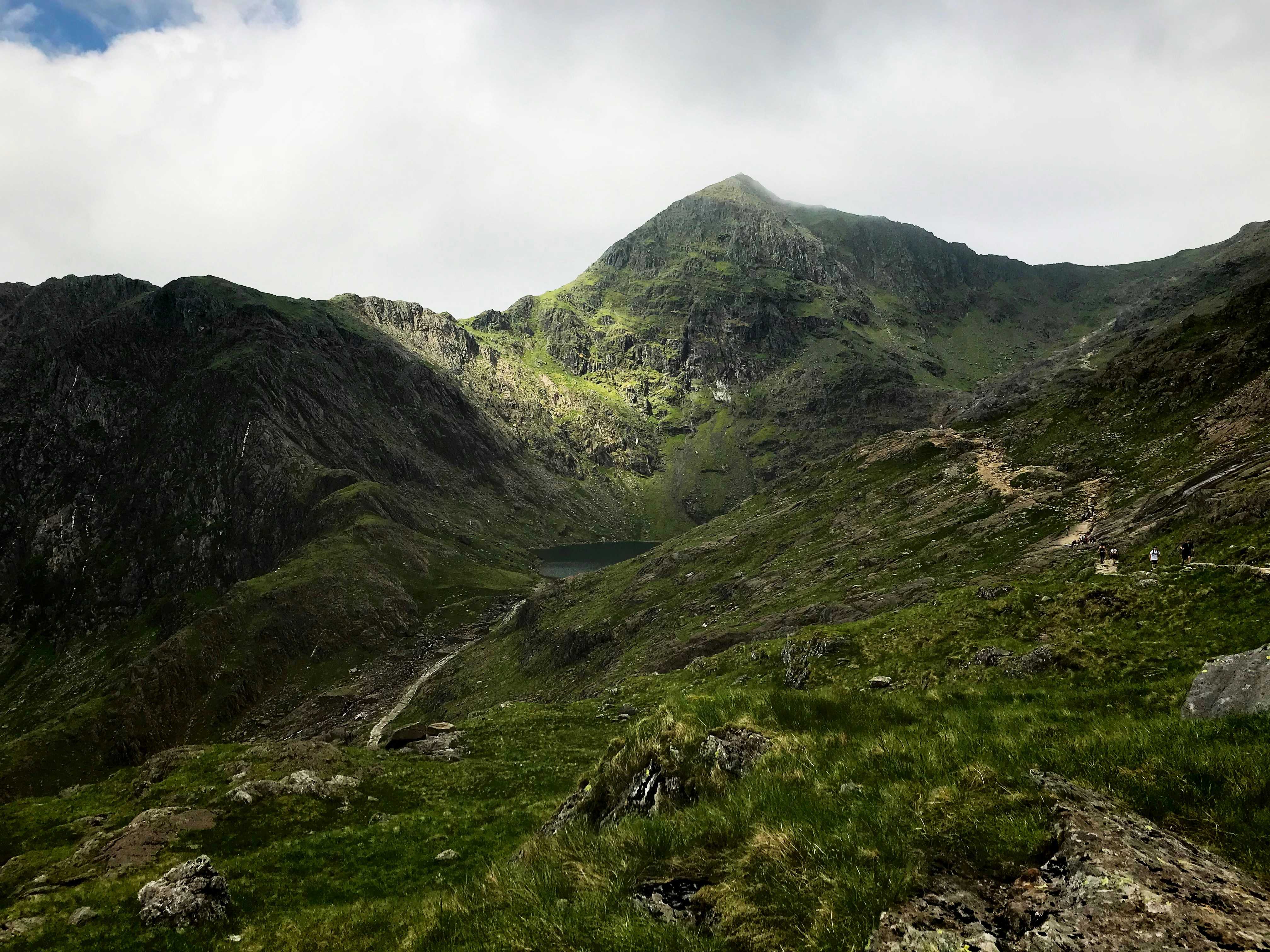
The Pyg Track to Snowdon summit
Whether you’re a keen hiker or an infrequent rambler, an ascent of Snowdon (or, to give it its preferred Welsh name, Yr Wyddfa) may well be on your walking bucket list. If you’re planning to head to the summit, then you may be pleased to note that the Pyg Track is the shortest of the six routes to the top. Do bear in mind, though, that the shortest route isn’t the easiest way to walk Snowdon (for that you’ll want the longer but gentler Llanberis Path). Considered the ‘classic’ Snowdon path, the Pyg’s final ascent is quite tough so save your energy on the ‘easier’ early sections.
Pick up the Pyg Track from the car park at Pen-y-Pass. The name of the path comes from ‘pyg’, the local term for black tar that was carried to the copper mines of Snowdon. The immense cliffs of Crib Goch and Y Lliwedd tower either side of the route as the climb reaches the Llyn Llydaw and Glaslyn lakes. The Pyg Track is signposted and the latter stages twist and turn, following sections of the Snowdon Mountain Railway. A final burst up the steps to the summit makes for a memorable experience. For a different descent, make your way down the Miners’ Track back to the start.
Happy Valley and the Bearded Lake
A relatively short walk of four miles explores Happy Valley, the name given to Cwm Maethlon vale by the Victorians. The walk offers views of the Dysynni Estuary, crosses the Afon Dyffryn Gwyn River, passes a prehistoric stone circle and reaches the ‘Bearded Lake’ before returning via farmland along the line of the valley. Llyn Barfog, aka the Bearded Lake, is a local beauty spot filled with legends of King Arthur.
It’s said the mythical knight thwarted the ‘Afanc’ beast and dumped it in the water so it wouldn’t bother the local town and villages any longer. Look out for the Carn March Arthur rock, in which it is said you can still make out the hoofprint of Arthur’s horse. An inscribed stone marks the spot.
The Porthor and Whistling Sands walk
If you whistle while you walk, you’ll be right at home on this easy trail of around a mile in length. The waymarked route on the north coast of the Llŷn Peninsula makes its way above the sandy cove of Porth Oer, also known as Whistling Sands because of the unique squeak the dry sand makes when you step on it.
Starting from the car park at Carreg, the circular walk loops around the base of the Mynydd Mawr summit. The signposted trail heads through farmland footpaths, then along a stretch of the Wales Coast Path above the beach with views of Dinas Bach and the Dinas Fawr headlands. Take a detour onto the beach to experience making music with your feet before returning past a former quarry where distinctive red jasper was once dug for.
Planning to spend a bit of time exploring everything this area has to offer? Check out our guide to the best beaches in Gwynedd and a list of our favourite things to do in the area – and then get booking. Camping and glamping are both great ways to experience this scenic part of the country, and with prices starting from just £15 per night you could be treating yourselves to mountain or coast views without breaking the bank. Click the link below to see what’s available.