Snittlegarth
View prices & book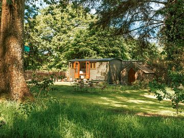


/-3.214288923776536,54.730442378488675,12,0,0/376x277@2x)
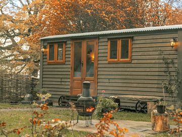
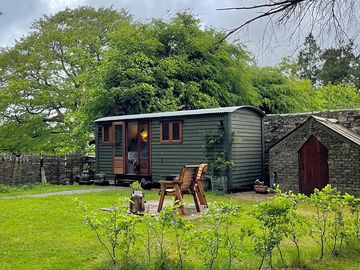
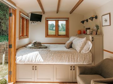
- Cosy single shepherd's hut in woods on a Cumbria Farm
- In the northern Lake District, 20 minutes' drive from Keswick
- Ensuite hut with firepit, kingsize bed and well-equipped kitchen
Campground type
 Under 18s must be accompanied by their parents or legal guardians.
- The campground/park does not accept breeds/crossbreeds listed in the Dangerous Dog Act (i.e. Pit Bull Terrier, Japanese Tosa, Dogo Argentino, and Fila Brasileiro).
- No hen/stag parties permitted via Pitchup.com.
Languages spoken
![]() English
English

Reviews
No reviews yet.
Features
Dogs allowed
Leisure on site
Bar or club house Cycle hire Evening entertainment Fishing Fitness centre Games room Indoor swimming pool Kids' club On-site restaurant/cafe Outdoor swimming pool Play area TV room Take away Tennis WatersportsAmenities on site
Bath available Composting toilet Dog park Drying room Food shop Free wifi Ice pack freezing Internet access Laundry Parent & baby washroom Pick-up from public transport Portable toilet Pub toilets Public telephone Shower available Toilet block Washing-up area WifiGroups welcome
Family friendly Motorcycle friendly Single-sex groups welcome Student groups welcomeRules
Barbecue provided Barbecues allowed Campfires allowed Commercial vehicles allowed Dogs allowed Dogs allowed all yearThemes
PeacefulUtilities
Charging facilities Dump point Electric car charging point(s) Gas cylinders available Recycling available Renewable energyNearby amenities
Bar nearby Dog walk nearbyType
Tiny (1-10 sites)Location
Snittlegarth
Ireby
Wigton
Cumbria
England
CA7 1HE
Timezone
Europe/London +0100 (GMT+01:00)
GPS
54.73044°N
3.21429°W
Nearest transport
Please note: All distances on this page are calculated "as the crow flies" - please check actual distance depending on your mode of travel using the Get directions button above.
Local attractions
Water quality at nearby bathing waters
| Name | Distance | Type | 2020 | 2019 | 2018 | 2017 |
|---|---|---|---|---|---|---|
| Allonby | 14.7 km | Sea | N/A | Good | Good | Good |
| Southerness | 29.5 km | Sea | N/A | Good | Good | Excellent |
| Sandyhills | 36.6 km | Sea | N/A | N/A | Poor | Poor |
| St Bees | 36.9 km | Sea | N/A | Excellent | Excellent | Excellent |
| Rockcliffe | 40.2 km | Estuary | N/A | Poor | Poor | Poor |
Data source: European Environment Agency
Must see
Mirehouse Historic House and Gardens 9.9 km
Whinlatter Forest & Visitor Centre 13.9 km
Castlerigg Stone Circle 16 km
Carlisle Castle 25.4 km
Ullswater Steamers 27.1 km
National Trust
Wordsworth House and Garden 12.4 km
Buttermere and Ennerdale 30.2 km
Grasmere and Great Langdale 34.8 km
Wasdale, Eskdale and Duddon 35.2 km
Townend 40.5 km
Cycle routes
Find local routes on the National Cycle Network - over 12,000 miles of cycling routes.
Other
High Pike, Fellside 8.5 km
Ullock Pike - Longside Edge - Skiddaw 8.6 km
Dodd Wood under Ullock Pike 9.9 km
Bassenthwaite Osprey Walk 9.9 km
Cockermouth - River Cocker 12.1 km
Local events
- Kendal Calling (Thursday 30 July 2026 – Thursday 30 July 2026)
Penrith, England 35 km
Please note: All distances on this page are calculated "as the crow flies" - please check actual distance depending on your mode of travel using the Get directions button above.
Want to know more about camping in The Lake District and Cumbria?
- Climbing in the Lake District
- 8 Scenic Cumbria Walks To Try
- Wildlife in the Lake District National Park
- Lake District Area Guide
- Our 8 Top Things To Do In Cumbria
- 5 Best Beaches In Cumbria To Visit
- Must-Visit Lake District Peaks
- The Ultimate North West England Camping Guide
- North West England Area Guide
- Pitchup.com's camping guide
- Essential camping checklist
Frequently asked questions
- Does Snittlegarth have a swimming pool? No View all features
- Is Snittlegarth dog friendly? Yes View all features
- What attractions are near Snittlegarth? Bring your best hiking boots along, because there are loads of great trails to try out around here. Adventurous sorts can scale Skiddaw (20 minutes’ drive) or Blencathra (half an hour) or … Read more
- When can I check in and check out of Snittlegarth?
Read moreOn-site accommodation Arrive: 3 p.m. – 10 p.m. Depart by: 10 a.m. - How much does it cost to stay at Snittlegarth? From $231.22 (for 1 night, 2 adults) - prices may change depending on your dates and party.