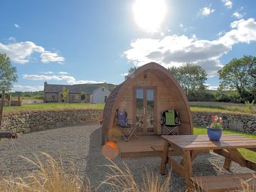
Bluebell Lane Glamping
No momento, este local não está aceitando reservas aqui no Pitchup.com
Se você é o proprietário deste local, comece a fazer reservas no Pitchup.com.
É grátis, rápido e fácil!
- Glamping no sul de Armagh com linda vista do Ring of Gullion
- Em área de exuberante beleza natural
- Instalações modernas, área de lazer, churrascos e fogueiras permitidos
Tipo de local
Idiomas falados
![]() Inglês
Inglês
Locais mais próximos

Infelizmente não temos locais que recebem reservas automaticamente nos arredores.
Recursos
![]() Não permitido cachorros
Não permitido cachorros
![]() Fogueiras permitidas
Fogueiras permitidas
Lazer no local
Academia
Aluguel de bicicletas
Bar ou clube
Clube infantil
Entretenimento noturno
Esportes aquáticos
Parque infantil
Pescaria
Piscina aquecida
Piscina externa
Restaurante no local
Sala de TV
Sala de jogos
Tele-entrega
Tênis
Instalações no local
Acesso à internet
Banheiras disponíveis
Banheiro ecológico
Banheiro portátil
Banheiros no pub
Banheiros para famílias
Chuveiros disponíveis
Congelamento de compressa fria
Estacionamento ao lado do local/da unidade
Instalações para pessoas com deficiência
Lavanderia
Local para lavar louça
Mercado
Parque para cachorros
Produtos locais
Prédio de banheiros
Sala de secagem
Serviço de transfer
Telefone público
Tendas para alugar
Wifi
Wifi grátis
Grupos bem-vindos
Familiar
Grupos de estudantes bem-vindos
Grupos de pessoas do mesmo sexo bem-vindos
Motocicletas bem-vindas
Regras
Cachorros permitidos
Churrasqueira fornecida
Fogueiras permitidas
Não permitido cachorros
Permitido fazer churrasco
Veículos comerciais permitidos
Temas
Campismo selvagem
Econômico/Mochileiro
Floresta
Lago e/ou montanha
Local remoto
Paisagens espetaculares
Paraíso natural
Paraíso para caminhadas
Tranquilo
Serviços
Cilindros de gás disponíveis
Eliminação de toiletes químicos
Energia renovável
Infraestrutura de recarga
Ponto(s) para carregar veículos elétricos
Reciclagem disponível
Instalações nos arredores
Bar nas redondezas
Lojas das redondezas
Lugar para passear com cachorros por perto
Transportes públicos nas proximidades
Tipo
Fazenda
Mini (1-10 unidades)
Lazer nos arredores
Aluguel de bicicletas nos arredores
Canoagem/caiaque nos arredores
Ciclovias nos arredores
Equitação nas redondezas
Golf nas redondezas
Pescaria nas redondezas
Trailers e Motor-casas
Conexão de água para caravanas
Conexão para drenagem para caravanas
Estação de serviço para motor-casa
Local
Bluebell Lane Glamping
49 Tullymacrieve rd
Mullaghbawn
Newry
Co. Down
Irlanda Do Norte
BT35 9RE
Fuso horário
Europe/London +0000 (GMT+00:00)
GPS
54,12016°N
-6,49422°O
Observe o seguinte: Todas as distâncias nesta página são calculadas em linha reta - verifique a distância real, dependendo da forma com que você viaja, no botão 'Saiba como chegar' acima.
Atrações locais
A qualidade da água em locais de banho próximos
| Nome | Distância | Tipo | 2020 | 2019 | 2018 | 2017 |
|---|---|---|---|---|---|---|
| Shelling Hill/Templetown | 27,4 km | Mar | Excelente | Excelente | Excelente | Excelente |
| Cranfield (Cranfield Bay) | 29,4 km | Mar | Excelente | Excelente | Excelente | Excelente |
| Port, Lurganboy | 36,1 km | Mar | Excelente | Excelente | Excelente | Excelente |
| Clogherhead | 40,9 km | Mar | Excelente | Excelente | Excelente | Excelente |
| Newcastle | 41 km | Mar | N/A | N/A | N/A | N/A |
Fonte de dados: European Environment Agency
National Trust
Derrymore House 10,5 km
Ardress House 36,7 km
The Argory 39,3 km
Ciclovias
Encontre rotas locais na National Cycle Network - mais de 19.000 km de ciclovias.
Outro
CARLINGFORD LOUGH ISLANDS (CURRENT BOUNDARY FROM 15/02/1996) 28 km
Observe o seguinte: Todas as distâncias nesta página são calculadas em linha reta - verifique a distância real, dependendo da forma com que você viaja, no botão 'Saiba como chegar' acima.
Avaliações
Nenhuma avaliação ainda.
- O Bluebell Lane Glamping tem uma piscina? Não Visualizar todas as características
- O Bluebell Lane Glamping aceita cachorros? Não Visualizar todas as características
- Quais atrações ficam perto do Bluebell Lane Glamping? The famed Ring of Gullion, the first ring dike in the world to be geologically mapped, sits atop famed Slieve Gullion, the highest peak in County Armagh. Clamber up here if you … Saiba mais
- Quando posso fazer check-in e check-out do Bluebell Lane Glamping?
Saiba maisCamping e turismo Chega: 15:00 – 21:00 Partida às: 10:30 Acomodação no local Chega: 15:00 – 21:00 Partida às: 10:30